Discover the intriguing past of Lowestoft's historic beach village; once home to a thriving fishing community.
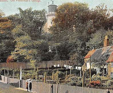
Since the early part of the C16th, there have been houses in Lowestoft along the base of the cliff alongside the bottom of what became known as Gowings Score (and later, and to this day, Martin’s Score). The historian Edmund Gillingwater recorded that 76 tenements were erected between 1791 – 1806 on the Denes - the extreme east of Lowestoft. These were the start of what became known as the Beach Village, or (by the folk who lived there) the Beach, a “town below the cliff”.

By 1812, a guide book stated that “the buildings had become so numerous that had they been built more compactly, they would have been sufficient to form a small town themselves". By the end of the century, that is precisely what happened.
Lowestoft was a town with an obvious and long association with the sea. Men based in the town facing out to the harsh North Sea had fished since before the Middle Ages, believing primitively that the sun rose on it before any other in England as good fortune for the town and its inhabitants, offering the first, and best, catch of the day.
By the end of the 18th century, the amount of residents earning a living from the sea was such that these very basic shanty houses started to emerge as noted by Gillingwater. But in the first half of the C19th, the industrial efforts of Samuel Morton Peto caused Lowestoft’s fishing trade to move into the stratosphere. In 1837, Lowestoft was granted the status of port town and in 1942, Peto opened the railway between Lowestoft to both Ipswich and Norwich, meaning the fishing trade could take advantage of its unique infrastructure. Peto declared that the opening of the line “would enable fresh fish from Lowestoft to arrive in Manchester in time for the customary local High Tea”.
Following these events, the Beach Village became hugely overpopulated with, at its height, over 2,700 people living in just 500 very small homes. Almost everybody living on the Beach Village worked in the fishing industry or one of the many supporting industries which sprung up as a result of Peto’s endeavours, such as; net, rope and sail-makers, ship lamp-makers and repairers too. Most houses had strict building conditions which meant the buildings could not exceed a certain height - it was not at all uncommon for a family of between five to ten to live in a one or two-bedroom house.

All these people supported many other businesses too. The Beach had 13 pubs and even its own brewery. As well as this; newsagents, several bakeries, grocers, a dairy, a butchers (with its own abbatoir!) and even a barbers. This all meant that for many, they never had to leave the surroundings of the “town below the cliff”.
Janet Sawyer, whose grandparents lived in Lowestoft High Street, says she remembers her grandfather telling her of the Beach Village and occasionally seeing people venture up through the Scores (a series of narrow lanes created over the years by people wearing paths in the soft, sloping cliff as they travelled between the High Street and the Beach Village) and that he could always tell if they lived on ‘the Grit’. “Often it was obvious (she recalls him saying) – no shoes, very dirty. Not quite a dialect but words or smudges (sic) of words that wouldn’t be heard elsewhere. But aside from these things, there was something about them that gave it away.”
Over the next 70 years, The Beach Village continued to prosper and thrive and even saw some its streets named in 1863 by the National Paving Committee. Then WWI came and it is thought that the decline of the Beach Village can be traced to this. Some of the fishing fleet belonging to the men of the village commissioned for national and military use putting pay to fishing but also during this time, the Beach Village was bombarded by the German fleet who were trying to bomb the Gasworks.
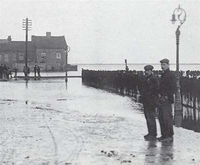
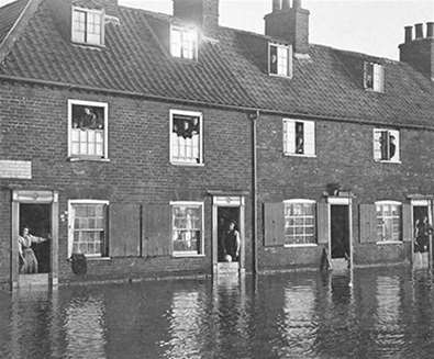
This, along with major flooding in 1916, 1925 and 1929 to a height of up to 2 feet across the whole of the Beach Village, meant that the area was generally considered a slum area and unfit for habitation.
In 1933, Lowestoft council declared the Beach a clearance area and published in the Lowestoft Journal that “houses were badly arranged, worn-out and dilapidated beyond repair” and in a 1935 council meeting recording that they were to “redevelop the area, possibly into a housing estate”. This gained pace in 1937 with new houses being built in Lighthouse Score but those houses were all that were erected as far as the residential aspect of the redevelopment went.

WWII came and went, further decimating the area and in 1949, Birds Eye opened a depot which was developed by 1952 into a production unit with further growth following. The following year - 1953, the worst flooding in history of the east coast occurred and devastated 400 homes and two years after that, the Lowestoft Journal reported on ‘the First Stage of Slum Clearance’ concerning the area to the east of Whapload Road.
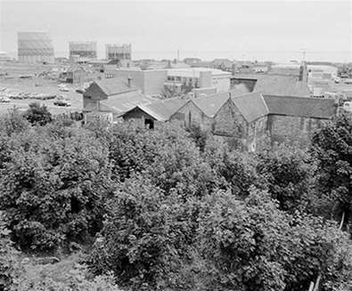
The redevelopment gradually continued over the next twenty years as new industry moved in and old residents were rehoused. Nowadays, little remains that offers much proof of the bustling Village or its many residents. However, if you are inclined to spend some time walking around the area, there are still some clues and the Heritage Workshop Centre on Wildes Score has a scaled model of the Village.

For more information on the Beach Village, join the Facebook group at www.facebook.com/groups/beachvillagelowestoft